The Allied Mapmakers of World War II: Army Map Service, Ordnance Survey and Beyond
NavWarMap No. 4, The North Pacific Area, U.S. Navy, 1944
The Maps of World War II · Chapter 6 of 9 · The map factories
Allied mapmakers
No war consumed maps like the Second World War. Behind the front stood an industry of surveyors, draftsmen, photographers and printers on three continents.
The Army Map Service
In 1942 the U.S. Army reorganized its engineer mapping offices in Washington into the Army Map Service. Its job was to supply every American force in the world with maps, and it did so on an industrial scale, compiling new sheets from aerial photographs, copying captured and foreign maps, and printing them by the million. In the field, engineer topographic battalions carried presses in trucks and trailers so that sheets could be revised and reprinted within hours of a new reconnaissance. Many of the plain, practical sheets in this collection carry the line “Prepared by the Army Map Service.”
Britain: the War Office and the Ordnance Survey
Britain’s military maps came from the War Office’s Geographical Section, General Staff, whose series numbers, “GSGS,” appear in the margins of sheets from Norway to Burma. Its 1:50,000 map of France, GSGS 4250, was the map of the Normandy campaign. The Ordnance Survey printed much of the output; its Southampton offices were badly damaged by bombing in 1940, and production moved and carried on. For the invasion of Europe, the Inter-Services Topographical Department in Oxford gathered topographical intelligence on every coast the Allies might land on, including millions of holiday snapshots and postcards sent in by the public after a 1942 appeal.
Strategists and teachers
Not every Allied map was made for the front. In Washington, the Office of Strategic Services had a map division whose cartographers included Arthur H. Robinson, later famous for the Robinson projection. The U.S. Navy issued large wall maps for training and orientation, such as the 1944 NavWarMap series in this gallery, each a full theater of the naval war with explanatory text. The Allied armies of Britain, Canada, Australia, India and the Soviet Union all ran their own survey services, and the Free French and the governments-in-exile drew on prewar national surveys of their occupied homelands.
NavWarMaps: the naval war, theater by theater: 7 sheets.
Allied maps and mapmakers
U.S., British, Commonwealth and Allied maps, NavWarMaps and the work of the map factories. Filter by maker, type and year. 99 maps in 5 groups: Made in United States, Other and unattributed makers, Made in Britain and the Commonwealth, Made in Soviet Union, Made in Germany.
Made in United States (1 of 2) 27 maps
Plano-de-la-Ciudad-de-Ceuta-1943U.S. Army Map Service · 1943 · Mediterranean & North Africa
Detail map of Ceuta, a Spanish exclave city on the Mediterranean Coast of Morocco.
Public domain. Sourceخريطة الرباط سلا 1942Geographical Section, General Staff No. 4241 Army Map Service, US Army, Washington DC,… · 1942 · Mediterranean & North Africa
1942 في الاستعداد للتنشط في المغرب خلال الحرب العالمية الثانية
Morocco City Plans – Perry-Castañeda Map Collection – UT Library Online. Public domain. Sourceخريطة الدار البيضاء 1942Geographical Section, General Staff No. 4241 Army Map Service, US Army, Washington DC,… · 1942 · Mediterranean & North Africa
1942 في الاستعداد للتنشط في المغرب خلال الحرب العالمية الثانية
Morocco City Plans – Perry-Castañeda Map Collection – UT Library Online. Public domain. SourceTxu-pclmaps-oclc-6583553-island-of-madeiraU.S. Army Map Service · 1943 · World & home fronts
Island of Madeira 1:50,000 Series 4313, U.S. Army Map Service, 1943
University of Texas. Public domain. SourceGreat circle map showming Fairbanks, Alaska a geographical center of Europe, Asia, America and terminus of the Pacific…États-Unis. Army map service. Auteur du texte · 1943 · Pacific
Sujet : Distances Monde Échelle(s) : 1000 miles [= 0 m. 063 ; 1:25 000 000 environ] Langue : anglais Éditeur : Army Map Service (Washington)
Bibliothèque nationale de France. Public domain. SourceChina 1 : 25.000. Nanking [Kiang-Si]États-Unis. Army map service. Auteur du texte · 1945 · China, Burma & India
Sujet : Plans de ville Nankin — Environs Échelle(s) : 1:25 000 Couverture : Chine Langue : anglais Éditeur : Army Map Service
Bibliothèque nationale de France. Public domain. SourceIndia. Special strategic mapÉtats-Unis. Army map service. Auteur du texte · 1945 · China, Burma & India
Sujet : Stratégie Chemins de fer Indes, Empire des — Routes — Chemins de fer Échelle(s) : 1:1 000 000 Langue : anglais Éditeur : Army Map Service (Washington)
Bibliothèque nationale de France. Public domain. SourceIndia. Special strategic mapÉtats-Unis. Army map service. Auteur du texte · 1945 · China, Burma & India
Sujet : Stratégie Chemins de fer Indes, Empire des — Routes — Chemins de fer Échelle(s) : 1:1 000 000 Langue : anglais Éditeur : Army Map Service (Washington)
Bibliothèque nationale de France. Public domain. SourceTimor strategic 1943United States Army Map Service · 1943 · World & home fronts
Timor 1943 (286K) Portion of "Timor Special Strategic Map" U.S. Army Map Service, AMS 9101, 1943 [May 1955 printing]. Original scale 1:2,000,000.
Public domain. SourceTxu-pclmaps-oclc-6595558-Dilly-1943United States Army Map Service · 1943 · World & home fronts
Dilly 1943 Original Scale 1:250,000. U.S. Army Map Service, Series T551, Second Edition, 1943 (3.9MB).
Public domain. SourceManila and Suburbs (1943)Army Map Service, U.S. Army · 1943 · World & home fronts
Map of Manila and Suburbs (1943)
Public domain. Sourceالمدينة القديمة في خريطة للدار البيضاء 1942 (cropped)Geographical Section, General Staff No. 4241 Army Map Service, US Army, Washington DC,… · 1942 · Mediterranean & North Africa
1942 في الاستعداد للتنشط في المغرب خلال الحرب العالمية الثانية
Morocco City Plans – Perry-Castañeda Map Collection – UT Library Online. Public domain. SourceAlbay, Philippine Islands, Albay Province. A.M.S. S901 1944 (G8064.L497C2.1944.A7M3)United States Army Map Service · 1944 · Pacific
Publisher: Washington, D.C. : Army Map Service, U.S. Army, 1944. Access: Public Description: AMS 1. Alternate title: Albay. In upper left margin: Philippine Islands city plans. Copied from Military Infromation Division blueprint, 1904.
Public domain. SourceNavWarMap No. 1 – The MediterraneanBureau of Naval Personnel, · 1944 · Mediterranean & North Africa
1944 Map – NavWarMap No. 1 – The Mediterranean.
Public domain. SourceWorld War II Map – 1 – The MediterraneanEducational Service Section / U.S. Navy · 1944 · Mediterranean & North AfricaPublic domain. SourceNavWarMap No. 2 – The South China Sea AreaEducational Service Section / U.S. Navy · 1944 · China, Burma & India
World War II Map – 2 – The South China Sea Area
Public domain. SourceNavWarMap No. 3 – World War 2 in the North Sea AreaEducational Service Section / U.S. Navy · 1944 · Atlantic
Map of World War II in the North Sea Area
Public domain. SourceNavy War Map No. 2 – The South China Sea Area Bureau of Naval Personnel Navy Department · 1944 · China, Burma & IndiaPublic domain. SourceNavWarMap No. 4 – The North Pacific Area Bureau of Naval Personnel Navy Department · 1944 · PacificPublic domain. SourceNavWarMap No. 6 – We Fight a Global WarBureau of Naval Personnel Navy Department · 1944 · World & home frontsPublic domain. SourceNavWarMap No. 5 – Southwest PacificBureau of Naval Personnel Navy Department · 1944 · PacificPublic domain. SourceFrance, Series M661 (GSGS 4249), 1-100,000, U.S. Army Map Service, 1943, index mapU.S. Army Map Service · 1943 · Western EuropePublic domain. SourceMap by the US Army Map Service – Mogadiscio – africa 1m – txu-pclmaps-oclc-6587819-na-38United States Army Map Service · 1943 · Western Europe
Mogadiscio – Sheet NA 38, 1943 (3.2MB) – Africa, 1:1,000,000, Great Britain. War Office. General Staff. Geographical Section, 1913-, reissued by U.S. Army Map Service, 1942-
[1]. Public domain. SourceMap by the US Army Map Service – Banzyville – africa 1m – txu-pclmaps-oclc-6587819-nb-34United States Army Map Service · 1943 · Western Europe
Banzyville – Sheet NB 34, Provisional Edition, 1943 (3.9MB) – Africa, 1:1,000,000, Great Britain. War Office. General Staff. Geographical Section, 1913-, reissued by U.S. Army Map Service, 1942-
[1]. Public domain. SourceMap by the US Army Map Service – Mongalla – africa 1m – txu-pclmaps-oclc-6587819-nb-36United States Army Map Service · 1943 · Western Europe
Mongalla – Sheet NB 36, 1943 (6.3MB) – Africa, 1:1,000,000, Great Britain. War Office. General Staff. Geographical Section, 1913-, reissued by U.S. Army Map Service, 1942-
[1]. Public domain. SourceMap by the US Army Map Service – Harar – africa 1m – txu-pclmaps-oclc-6587819-nc-38United States Army Map Service · 1943 · Western Europe
Harar – Sheet NC 38, AMS 2, 1943 (3.9MB) – Africa, 1:1,000,000, Great Britain. War Office. General Staff. Geographical Section, 1913-, reissued by U.S. Army Map Service, 1942-
[1]. Public domain. SourceMap by the US Army Map Service – Abeche – africa 1m – txu-pclmaps-oclc-6587819-nd-34United States Army Map Service · 1943 · Western Europe
Abeche – Sheet ND 34, AMS 2, First Edition, 1943 (6.9MB) – Africa, 1:1,000,000, Great Britain. War Office. General Staff. Geographical Section, 1913-, reissued by U.S. Army Map Service, 1942-
Map by the US Army Map Service – Khartoum – africa 1m – txu-pclmaps-oclc-6587819-nd-36United States Army Map Service · 1944 · Western Europe
Khartoum – Sheet ND 36, AMS 3, Second Edition, 1944 (8.1MB) – Africa, 1:1,000,000, Great Britain. War Office. General Staff. Geographical Section, 1913-, reissued by U.S. Army Map Service, 1942-
[1]. Public domain. SourceU.S. Army Map Service, Paris 1944 – The University of Texas at AustinU.S. Army Map Service · 1944 · Western Europe
Map of Paris by U.S. Army Map Service.
France City Plans – The University of Texas at Austin. Public domain. SourceU.S. Army Map Service, Paris 1944 – MapsterU.S. Army Map Service · 1944 · Western Europe
Map of Paris by U.S. Army Map Service.
Mapster. Public domain. SourceMap of Nagaoka, Niigata Prefecture, Japan by U.S. Army Map Service 1944U.S. Army Map Service (Copied from map published by Japanese Imperial Land Survey) · 1944 · Pacific
Map of Nagaoka , Niigata Prefecture , Japan by U.S. Army Map Service , 1944. Copied from Sheet 65-4, 1:50,000, Japanese Imperial Land Survey, published 1934.
University of Texas Libraries. Public domain. Source1944 Plan of Shanghai by the U.S. Army Map Service – mergedU.S. Army Map Service · 1944 · China, Burma & IndiaPublic domain. Source1944 Plan of Shanghai by the U.S. Army Map Service – Sheet 2 of 2U.S. Army Map Service · 1944 · China, Burma & IndiaPublic domain. SourcePanama – Canal Zone and vicinityUS Army Map Service · 1947 · World & home frontsLibrary of Congress Geography and Map Division Washington, D.C. 20540-4650 USA DIGITAL ID g4872c pcc00002. Public domain. SourceCoe7478 largeUnited States Army Corps of Engineers · 1960 · World & home fronts
Shoulder patch insignia for the US Army Corps of Engineers, Army Map Service .
Author. Public domain. SourceCa. 1905 – 7 Sheet Military Map of Part of Southern ManchuriaUnited States War Dept. · 1905 · China, Burma & IndiaPublic domain. SourceDili 1943United States Army Map Service · 1943 · World & home fronts
Inset of File:Txu-pclmaps-oclc-6595558-Dilly-1943 focused on Dili
Public domain. SourceCleveland 1956 – PCL Map Collection – txu-pclmaps-topo-us-cleveland-1956United States government · World & home fronts
Cleveland 1956 (8.4 MB) – United States Topographic Maps 1:250,000
[1]. Public domain. SourceWWII-Poland-1939-communications and industryDepartment of History, United States Military Academy · 1939 · Eastern Front
Poland, 1939: communications and industry.
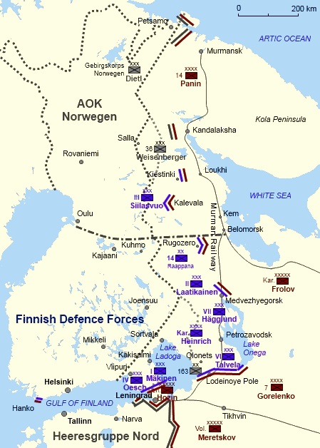
Public domain. SourceGerman withdrawal from Finland 1944 and 1945James F. Gebhardt · 1944 · Atlantic
US Army study map of the German withdrawal from Finland in late 1944 and early 1945
The Petsamo-Kirkenes Operation: Soviet breakthrough and pursuit in the Arctic, October 1944 .. Public domain. SourceRussian Balkans and Baltic Campaigns 19 August to 31 December 1944Department of History, United States Military Academy · 1944 · Mediterranean & North Africa
Military map of the Soviet Balkan and Baltic campaigns for World War II, during August 1944 to 31 December 1945
Public domain. SourceMap of Battle of Nevel (October 1943 – January 1944)Elliot Dunay, Office of the Chief of Military History, US Army · 1943 · Eastern Front
Map of Soviet/German Battle of Nevel (October 1943 – January 1944), Pskov Oblast/northeast Belarus. Battle of Nevel (1943).
Earl F. Ziemke, Stalingrad to Berlin, Center of Military History United States Army, Washington, DC, 1968, p.. Public domain. SourceSeal of the United States Army Corps of Engineers Army Map ServiceU.S. Army · 1968 · World & home fronts
Seal of the U.S. Army Map Service
This file was derived from: AMS.Insignia.jpg. Public domain. SourcePatch of the United States Army Corps of Engineers Army Map ServiceUnited States Army Corps of Engineers · 1969 · World & home fronts
Shoulder patch insignia for the US Army Corps of Engineers, Army Map Service .
Public domain. SourceLa Pextina (1945 Vol Americà sèrie A)1945 · World & home fronts
Fotografía aérea del barrio La Petxina tomada en 1945 por personal del Servicio de Mapas del Ejército ( Army Map Service ) de los Estados Unidos de América.
Institut Cartogràfic Valencià. [1]. CC BY 4.0. Source
Other and unattributed makers (1 of 2) 26 maps
Фронтовой документ коменданту гор. Жебрияны от 24 августа 1944 гNot credited · 1944 · World & home fronts
24 августа 1944 г. с просьбой об оказании помощи с мобилизацией рабочей силы, транспортом и лесоматериалами инженер-капитану Турбаевскому К. И. в строительстве причала для базирования в Жебриянах боевых кораблей Одесской ВМБ.
The document is owned by the descendants of Veselago, Tourbaevsky & Kazakov.. Public domain. SourceУдостоверение инженер-капитана Турбаевского К. И. от 24 августа 1944 гNot credited · 1944 · World & home frontsThe document is owned by the descendants of Veselago, Tourbaevsky & Kazakov.. Public domain. SourceКрасноармейская книжка Е. М. Добрышмана (1944) 03Not credited · 1944 · World & home fronts
1944 года старшины Е. М. Добрышмана (1919-2016), старшего метеоролога Одесской военной авиационной школы пилотов, в декабре 1941 года переброшенной в Киргизию.
Scanned by Alexey Tourbaevsky ( chelo Vechek / talk ) from original.. Public domain. SourceCaptured Pz.Kpfw. V ausf. Panther three days after the liberation in Uman, Ukraine on March 13th 1944Israel Ozersky · 1944 · Eastern FrontThis media is available in the holdings of the RIA Novosti , cataloged under the RIA Novosti Identifier…. Public domain. SourceOperation EFUser:Esquilo · 1941 · Western Europe
Launch point and targets for Operation EF in 1941.
File:Norway – Skogerøya, Finnmark.png. Public domain. SourceArmy G-2 Assesses German Victory (6 OCT 1939) – 9982652Erin Thompson · 1939 · Eastern Front
Operational Situation in Poland, Sept. 12, 1939 (from "Special Bulletin No. 1: The German Campaign in Poland," Oct. 6, 1939)
CC0. SourceOperation Arctic Fox XXXVI Corps AdvanceDead_Mary · Atlantic
Advance of the German XXXVI Corps during operation Arctix Fox – WWII
Created by WP User: Dead_Mary . Free to use for every purpose.. Public domain. SourceKarelo-Finnish SSR, 1941-1944Outline_Map_of_Karelia.svg : Виктор В derivative work: Semenov.m7 · 1941 · Eastern Front
Occupied territory of the Karelo-Finnish SSR in 1941-1944
Outline_Map_of_Karelia.svg licensed with PD-self information from the Encyclopedia "Karelia". Public domain. SourceБоевой путь 9 ПСДALDOR46 · 1944 · World & home fronts
9 -й Краснодарской Краснознамённой орденов Кутузова и КраснойЗвезды пластунской стрелковой дивизии.1944-1945 гг. (Схема).
Own work. CC BY-SA 3.0. SourceНаграды. Музей Диорама «Штурм Сапун-горы 7 мая 1944 г.». Севастополь. Крым. Россия. Май 2015 – panoramioVadim Indeikin · 1944 · World & home fronts
7 мая 1944 г.». Севастополь. Крым. Россия. Май 2015
CC BY-SA 3.0. SourceOperation Arctic Fox XXXVI Corps AdvanceРоман Рябенко · 2021 · Atlantic
Advance of the German XXXVI Corps during operation Arctix Fox – WWII
Own work based on: Operation Arctic Fox XXXVI Corps Advance.jpeg. CC0. SourceFinnish advance in Karelia during the Continuation WarUpload by Jniemenmaa · 1941 · Eastern FrontFrom English Wikipedia. CC BY-SA 3.0. SourceContinuation-War-defensive-linesUser Jniemenmaa on en.wikipedia · 1944 · Eastern Front
Map of the Finnish defensive lines at Karelian Isthmus on the summer 1944: Easternmost Main line ( Päälinja in Finnish), then VT-line (Vammelsuu–Taipale line; VT-linja or Vammelsuun–Taipaleen linja in Finnish) and VKT-line (Viipuri–Kuparsaari–Taipale line;
Transferred from en.wikipedia to Commons. Uploaded using CommonsHelper or PushForCommons. CC BY-SA 3.0. SourceFinsk framryckning i Karelen under fortsattningskrigetOriginal author is Jniemenmaa . Names in English were changed to Swedish in September… · 1941 · Eastern Front
Karta över den finländska framryckningen i Karelen under Fortsättningskriget (1941–1944). Den grå linjen betecknar 1920 års riksgräns, som gällde fram till Vinterkriget (1939–1940).
Bilden hämtad från Image:Finnish advance in Karelia during the Continuation War.png och därefter redigerad…. CC BY-SA 3.0. SourceBattle of Kuuterselka (14-15 June 1944)Rr016 · 1944 · Eastern Front
Map showing the battle at Kuuterselkä, June 14-15 1944. Influenced by maps in Steven Zaloga’s "T-34 vs StuG III: Finland 1944:".
Own work. CC BY-SA 4.0. SourceSuurin SuomiWorld & home frontsPublic domain. SourcePoland 19391939 · Eastern FrontCC BY-SA 3.0. SourceOperation bagration battle wizebsk 1944 june 22-27Kl833x9 · 1944 · Eastern Front
Operation Bagration: Battle of Witebsk, Development 22nd – 26th June 1944, 2200
Own work. CC BY-SA 3.0. SourceArmia pomorze 1939Lonio17 · 1939 · World & home fronts
Położenie wielkich jednostek Armii "Pomorze" i wielkich jednostek niemieckich 01-09-1939
Own work. CC BY-SA 4.0. SourceArmia lodz 1939Lonio17 · 1939 · World & home fronts
Położenie wielkich jednostek Armii "Łódź" i wielkich jednostek niemieckich 29-08-1939 (rano)
Own work. CC BY-SA 4.0. SourceBitwa o Pomorze (1 września 1939)Rr016 · 1939 · World & home fronts
Strategic map of the Battle of Pomerania, 1 September 1939. Heavily influenced by Wojciech Zalewski’s "Wielki Atlas Kampanii Wrześniowej 1939".
Own work. CC BY-SA 2.0. SourceBitwa o Pomorze (3 września 1939)Rr016 · 1939 · World & home fronts
Strategic map of the Battle of Pomerania, 3 September 1939. Heavily influenced by Wojciech Zalewski’s "Wielki Atlas Kampanii Wrześniowej 1939".
Own work. CC BY-SA 2.0. SourceBitwa o Pomorze (2 września 1939)Rr016 · 1939 · World & home fronts
Strategic map of the Battle of Pomerania, 2 September 1939. Heavily influenced by Wojciech Zalewski’s "Wielki Atlas Kampanii Wrześniowej 1939".
Own work. CC BY-SA 2.0. SourceBitwa nad Osą (3 września 1939)Rr016 · 1939 · World & home fronts
Tactical map of the battle of Mełno, 3 September 1939. Heavily influenced by Wojciech Zalewski’s "Wielki Atlas Kampanii Wrześniowej 1939".
Own work. CC BY-SA 2.0. SourceBitwa nad Osą (1 września 1939)Rr016 · 1939 · World & home fronts
Tactical map of the battle of Mełno, 1 September 1939. Heavily influenced by Wojciech Zalewski’s "Wielki Atlas Kampanii Wrześniowej 1939".
Own work. CC BY-SA 2.0. SourceBitwa nad Osą (2 września 1939)Rr016 · 1939 · World & home fronts
Tactical map of the battle of Mełno, 2 September 1939. Heavily influenced by Wojciech Zalewski’s "Wielki Atlas Kampanii Wrześniowej 1939".
Imagen de A Silva en 1956 tomada por un vuelo americano.
PDP Impreso del mapa de Fondo. CC BY 4.0. SourceContinuation War December 1941 FinnishPeltimikko · 1941 · Eastern Front
Jatkosodan rintamatilanne joulukuussa 1941. Saksan armeijayksikkö tai rintamalinja Suomen armeijayksikkö tai rintamalinja Neuvostoliiton armeijayksikkö tai rintamalinja +++ Suomen valtiorajat: tumman harmaa 1940 (Moskovan rauha), vaalean harmaa 1920 (Tarton…
Paris by Geographical Section, General Staff, War Office, 1944 – Stanford LibrariesGreat Britain. War Office. General Staff. Geographical Section · 1944 · Western Europe
Insets: Bois de Vincennes; Bois de Boulogne. "For key to street names, etc. see G.S.G.S. (Misc) No. 106." "Copied from French plan dated 1938. Photolithographed by O.S. 1944". Shows: street names, principal buildings. Great Britain. War Office. General Staff.
Stanford Libraries. Public domain. SourceWar Office (Great Britain) – Paris, 1944 – McMaster UniversityGreat Britain. War Office. General Staff. Geographical Section · 1944 · Western Europe
GSGS (series); 4326. Sheet 48. This sheet was originally published by the Depot de la Guerre in 1839. It was mounted on linen and the gaps along the folds between paper panels show up as horizontal and vertical white lines in this reproduction.
Paris – McMaster University. Public domain. SourceRadom 1943Polish General Staff / British War Office · 1943 · Eastern Front
Old map of Radom Poland from 1943
Public domain. SourceBialystok 1943Polish General Staff / British War Office · 1943 · Eastern Front
Old maps of Bialystok Poland from 1943
Public domain. SourceGrodno – Hrodno 1943Polish General Staff / British War Office · 1943 · Eastern Front
Old maps of Grodno / Hrodno Belarus from 1943
Public domain. SourceRzeszow 1943Polish General Staff / British War Office · 1943 · Eastern Front
Old map of Rzeszow Poland from 1943
Public domain. SourceTorun 1943Polish General Staff / British War Office · 1943 · Eastern Front
Old map of Torun Poland from 1943
Public domain. Source1943 WWII map of Hannover, GermanyGreat Britain War Office/Digital Archive @ McMaster University Library · 1943 · Western Europe
1943 map of Hannover, Germany published by the Great Britain War Office during World War II.
CC BY-SA 2.5. SourceKingdom of Italy 1943XrysD · 1943 · Mediterranean & North Africa
Administrative map of the Kingdom of Italy on 1-VII-1943. showing regions and provinces. Source data: Italy 250k (AMS 508), Italy 100k (GSGS 4164), Italien 100k (Deutsche Heereskarte) courtesy of http://www.mapywig.org
Own work. CC BY-SA 4.0. SourceItalian Social Republic 1943 MapXrysD · 1943 · Mediterranean & North Africa
Administrative map of the Italian Social Republic on 25-IX-1943. showing regions and provinces. Source data: Italy 250k (AMS 508), Italy 100k (GSGS 4164), Italien 100k (Deutsche Heereskarte) courtesy of http://www.mapywig.org
Own work. CC BY-SA 4.0. SourceRegno d Italia 1943XrysD · 1943 · Mediterranean & North Africa
Mappa amministrativa del Regno d’Italia il 1-VII-1943. La mappa mostra regioni e province. Dati sorgenti: Italia 250k (AMS 508), Italia 100k (GSGS 4164), Italia 100k (Deutsche Heereskarte) a cura di http://www.mapywig.org
Own work. CC BY-SA 4.0. SourceRepubblica Sociale Italiana 1943 MappaXrysD · 1943 · Mediterranean & North Africa
Mappa amministrativa della Repubblica Sociale Italiana. La mappa mostra regioni e province. Dati sorgenti: Italia 250k (AMS 508), Italia 100k (GSGS 4164), Italia 100k (Deutsche Heereskarte) a cura di http://www.mapywig.org
Own work. CC BY-SA 4.0. SourceWorld War II uniforms, weapons, and equipment representing the Polish Army, Royal Air Force (Canadian pilot), and the…Alan Wilson · 2022 · Eastern FrontCC BY-SA 2.0. Source
Made in Soviet Union 10 maps
Finland was a devoted satellate of Nazy Germany till 1944 when it was finally crushed by Soviet troopsAndrey Korchagin · 1939 · Eastern FrontPublic domain. SourceContinuation-War-1941Upload by Jniemenmaa · 1941 · Eastern Front
Relative strengths of Finnish, German and Soviet troops at the start of the Continuation War in June 1941. Finnish borders before the Moscow Peace Treaty shown in light colour.
Transferred from en.wikipedia. CC BY-SA 3.0. SourceVörös csillag és 1944, Katolikus Temető, 2018 DombóvárGlobetrotter19 · 1944 · Eastern Front
Soviet war (memorial) grave in the Roman Catholic Cemetery. – Rákóczi and Hetényi streets corner, Dombóvár , Tolna County , Hungary
Own work. CC BY-SA 3.0. SourceSoviet memorial obelisk, 2020 SzobGlobetrotter19 · 1944 · Eastern Front
Old cemetery, sector II., line 22, place 8. Soviet memorial obelisk (remain), On the next line (23th and 24th) are the graves of the soviet soldiers †1944, †1945 – Tompa Mihály Street, Szob , Pest County , Hungary .
Own work. CC BY-SA 3.0. SourceSowjetischer Friedhof, Denkmal für ein unbekannter sowjetischer Soldat †1944-10-15, 2021 OrosházaGlobetrotter19 · 1944 · Eastern Front
Memorial grave to unknown soviet soldier†1944 with columns vases and Hungarian-Russian plaque inscription: "~An unknown Soviet soldier has sacrificed his life for world freedom 15. X. 1944.".
Own work. CC BY-SA 3.0. SourcePlan obozu w Starobielsku w 1940 rokuGruzin · 1940 · Eastern Front
A map of the camp for Polish prisoners of war held by the Soviet intelligence bureau or NKVD in Starobielsk (nowadays in Ukraine). The PoWs were regular army officers and reserve officers who had been taken captive by the Soviet Union after its attack on…
Own work. CC BY 4.0. SourceCт. л-т Никогосян В.Х. †1944, Пюшпёкладань, 2025 PüspökladányGlobetrotter19 · 1944 · Eastern Front
Cemetery, Soviet war grave memorial, separate gravestones to Hero of the Soviet Union guard captain Shikunov Nikolai Alekseevich 1922-1945; to Senior lieutenant Nikogosyan V.H. 1908-1945;
Own work. CC BY-SA 4.0. SourceГвардии-капитан Шикунов Николай Алексеевич †1944, Пюшпёкладань, 2025 PüspökladányGlobetrotter19 · 1944 · Eastern Front
Cemetery, Soviet military cemetery (plot), Soviet war grave memorial, separate gravestones to Hero of the Soviet Union guard captain Shikunov Nikolai Alekseevich 1922-1944; to Senior lieutenant Nikogosyan V.H. 1908-1944;
Own work. CC BY-SA 4.0. SourceFriedhof, Obelisk (1944), 2026 PilisvörösvárGlobetrotter19 · 1944 · Eastern Front
Cemetery, Soviet obelisk former Liberation memorial.An obelisk with a relief depicting a hammer and sickle. Inscription at the base:‘In memory of the Heroic Soviet Army’ / 25 December 1944.
Own work. CC BY-SA 4.0. SourceContinuation War December 1941 EnglishPeltimikko · 1941 · Eastern Front
Front of the Continuation War in December 1941. German unit or front line Finnish unit or front line Soviet unit or front line +++ Borderline of Finland: dark grey 1940 (Peace of Moscow), mild grey 1920 (Treaty of Tartu) +-+ Remit line between Finnish and…
Copy of Himmlers anti-partisan map Bandenlage Ost (1944) (original by Reichsführer-SS staff, copy/translation by Soviet… · 1944 · Eastern Front
Abbreviated copy of the secret German SS and police map "Bandenlage ‘Ost’" (The partisan situation in the East), showing the activity of Belarusian partisans in the period from February 16 to February 29, 1944.
Диктант Победы — 2026 . Музей Победы . Retrieved on 2026-07-26 .. Public domain. SourceRzeczpospolita 1939 Polish divisions1939 · Eastern FrontCC BY-SA 3.0. Source
U.S. Army Corps of Engineers, history of the Army Map Service.
National Library of Scotland, GSGS military map collections.
Ordnance Survey, history of the organization in the Second World War.
Library of Congress and Wikimedia Commons, items credited individually.
Images are public domain (mostly U.S. federal government works and expired copyrights) or openly licensed under Creative Commons, drawn from Wikimedia Commons and the archives credited on each map. Each image links to its source file and license. Images are served through the WordPress.com image CDN for fast loading on phones. Axis maps are reproduced as historical records.
Cookie Consent
We use cookies to improve your experience on our site. By using our site, you consent to cookies.
Essential cookies enable basic functions and are necessary for the proper function of the website.
Name
Description
Duration
Cookie Preferences
This cookie is used to store the user's cookie consent preferences.
30 days
These cookies are needed for adding comments on this website.
Name
Description
Duration
comment_author_url
Used to track the user across multiple sessions.
Session
comment_author
Used to track the user across multiple sessions.
Session
comment_author_email
Used to track the user across multiple sessions.
Session
Google's current Sign in with Google client library. It renders the Google sign-in button, or the One Tap prompt, so visitors can log in to your site with their Google account. It replaces the older Google Sign-In platform library.
Set on your own domain by the Sign in with Google client library. Records whether the visitor has dismissed the One Tap sign-in prompt and for how long it should stay hidden, plus the time the library last loaded and a browsing session id used for the same purpose. Sites that pass a custom state_cookie_name will see that name instead.
180 days
g_csrf_token
Set on your own domain by the Sign in with Google client library and submitted together with the sign-in credential, so your site can confirm the sign-in came from its own page and not from a forged cross-site request.
5 minutes
Statistics cookies collect information anonymously. This information helps us understand how visitors use our website.
Google Analytics is a powerful tool that tracks and analyzes website traffic for informed marketing decisions.
Used to distinguish new sessions and visits. This cookie is set when the GA.js javascript library is loaded and there is no existing __utmb cookie. The cookie is updated every time data is sent to the Google Analytics server.
30 minutes after last activity
__utmc
Used only with old Urchin versions of Google Analytics and not with GA.js. Was used to distinguish between new sessions and visits at the end of a session.
End of session (browser)
__utmz
Contains information about the traffic source or campaign that directed user to the website. The cookie is set when the GA.js javascript is loaded and updated when data is sent to the Google Anaytics server
6 months after last activity
__utmv
Contains custom information set by the web developer via the _setCustomVar method in Google Analytics. This cookie is updated every time new data is sent to the Google Analytics server.
2 years after last activity
__utmx
Used to determine whether a user is included in an A / B or Multivariate test.
18 months
_ga
ID used to identify users
2 years
_gali
Used by Google Analytics to determine which links on a page are being clicked
30 seconds
_ga_
ID used to identify users
2 years
_gid
ID used to identify users for 24 hours after last activity
24 hours
_gat
Used to monitor number of Google Analytics server requests when using Google Tag Manager
1 minute
__utma
ID used to identify users and sessions
2 years after last activity
__utmt
Used to monitor number of Google Analytics server requests
10 minutes
_gac_
Contains information related to marketing campaigns of the user. These are shared with Google AdWords / Google Ads when the Google Ads and Google Analytics accounts are linked together.
90 days
Jetpack's built-in visitor analytics. It records page views, referring sites, search terms, and outbound link clicks, and also carries the shared visitor-tracking library used by Jetpack Instant Search and WooCommerce Analytics.

 NavWarMap No. 4, The North Pacific Area, U.S. Navy, 1944