

Operation Iceberg · 1945
OKINAWA
The last great
island battle.
A quiet landing. A fortified island. A fleet under attack. And a civilian population caught in the typhoon of steel.
Amphibious vehicles approach the Hagushi beaches on 1 April 1945, p. 73. U.S. Army, Okinawa: The Last Battle (1948), via HyperWar. Official U.S. government photograph; public domain.
The whole battle
One island. Four interconnected wars.
On 1 April 1945, American soldiers and Marines landed on Okinawa expecting a battle at the beaches. The major resistance waited inland. What followed joined a grinding ground campaign, a sustained naval battle, a vast construction and medical effort, and a catastrophe for Okinawan civilians.
This collection follows all four. Move through the campaign on an original Army map, compare Shuri aerial photographs, examine a real museum patch, and follow the records behind the statistics.
Timeline spacing is an editorial sequence, not a uniform time scale. The final entry jumps to the postwar period.
The campaign atlas
Follow the fight south
Seven numbered stops connect the official Army map with photographs and the chapter record. Use the slider, select a marker, or play the campaign.

U.S. Army, map 5, Southern Okinawa. Markers are approximate interpretive locations. This map excludes Motobu and Ie Shima; use the whole-island map below for those operations.
Open the whole-island map in full resolution →Open the official plan-of-attack map →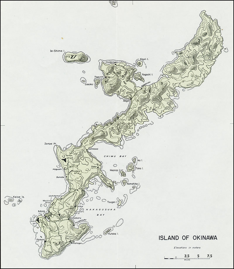

The nine-chapter collection
Read the battle from beginning to aftermath
0 of 9 chapters marked read
Reading marks are saved only in this browser.
Units & insignia
The patches and the men behind them
Select a unit’s story. The first image is a photograph of an identified surviving cloth patch; the other two reproduce genuine unit designs and are labelled accordingly.

1st Marine Division
The Old Breed fought through Dakeshi and Wana toward Shuri.
Open the unit story
The Old Breed fought through Dakeshi and Wana toward Shuri. Follow the campaign →


77th Infantry Division
The Statue of Liberty Division fought on Ie Shima and at Maeda Escarpment.
Open the unit story
The Statue of Liberty Division fought on Ie Shima and at Maeda Escarpment. Follow the campaign →


6th Marine Division
The division fought at Motobu, Sugar Loaf, Naha, and Oroku.
Open the unit story
The division fought at Motobu, Sugar Loaf, Naha, and Oroku. Follow the campaign →
Other major Army divisions: the 7th, 27th, and 96th. The 2nd Marine Division had a demonstration and reserve role. The Japanese 32nd Army included the 24th and 62nd Divisions and the 44th Independent Mixed Brigade. American order of battle · Japanese order of battle
The statistical record
Change the metric. Keep the definition.
Open the complete comparison table
| Division | Killed | Wounded | Missing | Battle total |
|---|---|---|---|---|
| 7th Infantry | 1,122 | 4,943 | 3 | 6,068 |
| 27th Infantry | 711 | 2,520 | 24 | 3,255 |
| 77th Infantry | 1,018 | 3,968 | 40 | 5,026 |
| 96th Infantry | 1,506 | 5,912 | 12 | 7,430 |
| 1st Marines | 1,115 | 6,745 | 41 | 7,901 |
| 6th Marines | 1,622 | 6,689 | 15 | 8,326 |
The same appendix reports 36 U.S. ships sunk, 368 damaged, and 763 aircraft lost; these are campaign totals and should not be described as losses caused exclusively by kamikazes. Table 2 →
The archive, compared
Shuri: April to May


Army official history, p. 399. The camera positions and framing differ; this is a documentary comparison, not a registered survey overlay. Original map annotations remain visible.
Lives in the record
Read beyond the battle map
Award citation
Desmond Doss
An Army aidman’s repeated rescues under fire. Read the full citation, including the actions after the escarpment rescue.
Open the record →Award citation
William Halyburton Jr.
The North Carolina corpsman killed shielding a wounded Marine on 10 May. His story connects Canton and Davidson to Okinawa.
Open the record →Survivor museum
The Himeyuri students
A museum founded by the surviving school community preserves the students’ medical service, loss, and testimony.
Open the record →Survivor testimony
Okinawan survivors
Hear the experiences that a divisional operations map cannot contain. The prefectural museum offers testimony in multiple languages.
Open the record →Biographical record
Ernie Pyle
The correspondent who wrote about ordinary servicemen was killed on Ie Shima on 18 April.
Open the record →Official-history photographs
The engineers
Follow the supply roads, bridge work, and casualty evacuation that kept Tenth Army operating.
Open the record →The photographic record
38 archival photographs
Select a photograph for full-screen viewing and its complete caption. Filter the collection or search its captions.
38 photographs shown


The research desk
100 questions, answered
100 questions shown
3. What were the main landing beaches?
The Hagushi beaches on Okinawa’s western coast.
Read chapter 2 and its sources →4. Who commanded Tenth Army?
Lt. Gen. Simon B. Buckner Jr. commanded it until his death on 18 June.
Read chapter 1 and its sources →6. Who directed the amphibious force?
Vice Adm. Richmond Kelly Turner.
Read chapter 1 and its sources →9. Who was Hiromichi Yahara?
The 32nd Army’s senior operations officer.
Read chapter 1 and its sources →10. Why did the Allies want Okinawa?
For airfields, anchorages, and a forward base for operations against Japan.
Read chapter 1 and its sources →11. Was Okinawa an empty military island?
No. It contained an established civilian society, farms, towns, and cultural sites.
Read chapter 1 and its sources →12. What was Shuri before the battle?
The old royal capital of the Ryukyu Kingdom and a major cultural center.
Read chapter 1 and its sources →13. Were all Okinawans Japanese soldiers?
No. Civilian residents must be distinguished from the garrison and locally mobilized personnel.
Read chapter 8 and its sources →14. Why were the beaches lightly defended?
The main Japanese defense concentrated inland, especially in the south.
Read chapter 2 and its sources →15. Did the easy landing mean an easy campaign?
No. The fortified southern defenses produced a prolonged battle.
Read chapter 2 and its sources →16. Which Marine divisions made the main landing?
The 1st and 6th Marine Divisions.
Read chapter 2 and its sources →17. Which Army divisions made the main landing?
The 7th and 96th Infantry Divisions.
Read chapter 2 and its sources →19. What was the 2nd Marine Division’s initial role?
A demonstration off southeastern Okinawa and a reserve role, rather than the same sustained advance as the assault divisions.
Read chapter 2 and its sources →21. Why did the reef matter?
It restricted which landing craft could reach shore at different tides.
Read chapter 2 and its sources →22. What were causeways used for?
Moving vehicles and supplies between landing ships and the beach.
Read chapter 2 and its sources →23. Did the beachhead need hospitals immediately?
Yes. Medical facilities and evacuation arrangements followed the assault.
Read chapter 7 and its sources →24. What did engineers do to captured runways?
Repair and expand them for Allied aircraft.
Read chapter 7 and its sources →25. What was the northern objective around Motobu?
Reducing Japanese positions in the rugged Yae-Take area.
Read chapter 3 and its sources →28. Why was Ie Shima important?
Its airfields and location made it a valuable supporting objective.
Read chapter 3 and its sources →31. What was the Pinnacle?
Iegusugu, the prominent central height on Ie Shima.
Read chapter 3 and its sources →32. Where was Ernie Pyle killed?
On Ie Shima, rather than on the main island of Okinawa.
Read chapter 3 and its sources →34. Why did Pyle’s death resonate?
His reporting made ordinary servicemen’s experiences familiar to readers.
Read chapter 3 and its sources →35. Did the 77th later fight in southern Okinawa?
Yes. Its campaign continued in the southern defenses after Ie Shima.
Read chapter 3 and its sources →36. What does the 77th Division insignia depict?
The Statue of Liberty.
Read chapter 3 and its sources →37. What was the Shuri Line?
A system of mutually supporting defensive positions, not a single continuous wall.
Read chapter 4 and its sources →38. Why were reverse slopes useful to defenders?
They reduced direct observation and sheltered positions from some incoming fire.
Read chapter 4 and its sources →39. Why did taking a crest not always end resistance?
Defenders could remain active in caves, tunnels, and neighboring positions.
Read chapter 4 and its sources →40. What is Hacksaw Ridge’s historical location?
Maeda Escarpment near Urasoe.
Read chapter 4 and its sources →41. Which division fought at Maeda?
The Army’s 77th Infantry Division.
Read chapter 4 and its sources →42. Was Desmond Doss a Marine?
No. He was an Army aidman with the 307th Infantry.
Read chapter 4 and its sources →43. Which regiment did Doss serve with?
The 307th Infantry, 77th Infantry Division.
Read chapter 4 and its sources →44. What dates does Doss’s Medal of Honor citation cover?
29 April through 21 May 1945.
Read chapter 4 and its sources →45. How did Doss evacuate men from the escarpment?
The citation describes moving casualties to the edge and lowering them with a rope-supported litter.
Read chapter 4 and its sources →46. Is Hacksaw Ridge a complete documentary record?
No. Compare its dramatization with the citation, official history, and battlefield maps.
Read chapter 4 and its sources →47. Were Doss’s actions confined to one rescue?
No. His citation records multiple actions over several weeks.
Read chapter 4 and its sources →48. What were armored flamethrowers used against?
Fortified positions, including cave defenses.
Read chapter 4 and its sources →49. Why did tanks need infantry protection?
Close-range attackers and concealed positions threatened tanks in broken terrain.
Read chapter 4 and its sources →50. What made Sugar Loaf difficult?
It was part of a mutually supporting hill complex.
Read chapter 5 and its sources →51. Which hills supported Sugar Loaf?
Horseshoe and Half Moon were key supporting positions.
Read chapter 5 and its sources →53. Where did the 1st Marine Division fight in May?
Among its major objectives were Dakeshi and Wana on the approach to Shuri.
Read chapter 5 and its sources →54. Why did rain matter tactically?
Mud restricted vehicle movement, supply, and casualty evacuation.
Read chapter 5 and its sources →55. Did the fall of Shuri end the campaign?
No. The Japanese withdrew to positions farther south.
Read chapter 5 and its sources →56. What do the paired Shuri aerial photographs show?
The city on 28 April and 23 May 1945.
Read chapter 5 and its sources →57. Are the Shuri pictures perfectly aligned?
No. They were taken from different camera positions.
Read chapter 5 and its sources →58. Can an aerial photograph identify every cause of destruction?
No. That requires additional evidence.
Read chapter 5 and its sources →59. What did Shuri Castle’s destruction mean beyond tactics?
The battle devastated a central site of Okinawan cultural history.
Read chapter 5 and its sources →60. Why did the fleet remain vulnerable?
Ships had to remain nearby to land, supply, protect, and support the troops.
Read chapter 6 and its sources →61. What was a radar picket?
A ship stationed away from the main force to provide warning and assist interception.
Read chapter 6 and its sources →62. Why were pickets attacked heavily?
They were often among the first ships incoming aircraft encountered.
Read chapter 6 and its sources →63. What were Kikusui attacks?
Mass Japanese special air attacks against the Okinawa force.
Read chapter 6 and its sources →65. What happened to Yamato?
American carrier aircraft sank her on 7 April before she could reach Okinawa.
Read chapter 6 and its sources →68. What kept many damaged ships afloat?
Damage-control parties containing fires, flooding, and other damage.
Read chapter 6 and its sources →69. Did Britain participate?
Yes. The British Pacific Fleet struck supporting Japanese airfields, notably in the Sakishima Islands.
Read chapter 6 and its sources →70. Where can I read more about the attackers?
Open the companion Kamikaze collection linked in this exhibit.
Read chapter 6 and its sources →71. Why did logistics determine the pace of advance?
Forward troops needed supplies even when roads could no longer support normal traffic.
Read chapter 7 and its sources →72. What road work did engineers perform?
Widening, surfacing, repair, bridge work, and vehicle recovery.
Read chapter 7 and its sources →73. What local material helped build roads?
Coral and limestone were among the materials used.
Read chapter 7 and its sources →74. Which engineers appear pulling trucks in the exhibit?
The 302d Combat Engineers, identified in the Army history’s caption.
Read chapter 7 and its sources →75. Did base construction wait for the fighting to end?
No. Airfields and supporting installations developed during the campaign.
Read chapter 7 and its sources →76. Why were litter bearers at risk?
They crossed the same exposed or shelled terrain as the troops they evacuated.
Read chapter 7 and its sources →77. Where did wounded men go?
Through aid stations and hospitals, with evacuation to ships or by aircraft as appropriate.
Read chapter 7 and its sources →78. Who was William Halyburton Jr.?
A Navy corpsman serving with the 2nd Battalion, 5th Marines, 1st Marine Division.
Read chapter 7 and its sources →79. When was Halyburton killed?
10 May 1945, while protecting a wounded Marine.
Read chapter 7 and its sources →80. What is Halyburton’s North Carolina connection?
He was born in Canton and studied at Davidson College before his military service.
Read chapter 7 and its sources →81. What is the typhoon of steel?
A name associated with the overwhelming bombardment and destruction of the Okinawa campaign.
Read chapter 8 and its sources →82. Were caves always safe for civilians?
No. Caves could provide shelter or become traps and military targets.
Read chapter 8 and its sources →83. What harms does Okinawan testimony document?
Bombardment, killings, coercion, hunger, flight, and family loss, with circumstances varying by place.
Read chapter 8 and its sources →84. Who were the Himeyuri students?
Students mobilized with their teachers for medical service during the battle.
Read chapter 8 and its sources →85. How many students and teachers were mobilized in that group?
The Himeyuri museum records 222 students and 18 teachers.
Read chapter 8 and its sources →86. How many mobilized Himeyuri members died?
The museum identifies 136 deaths among the mobilized group.
Read chapter 8 and its sources →87. Why is the cenotaph’s total different?
It also commemorates other students and teachers beyond the mobilized group.
Read chapter 8 and its sources →88. What did military-government camps do?
They gathered displaced residents and organized registration, relief, and medical services under occupation.
Read chapter 8 and its sources →89. Are military photographs a complete civilian account?
No. Read them alongside survivor testimony and civilian records.
Read chapter 8 and its sources →90. Why do civilian death totals differ?
Sources vary in scope, definitions, inclusion of locally mobilized personnel, and evidence.
Read chapter 8 and its sources →91. Where was the final Japanese command area?
Near Mabuni and Hill 89 on the southern coast.
Read chapter 9 and its sources →92. Where was the Japanese naval force’s last major defense?
Oroku Peninsula.
Read chapter 9 and its sources →95. When was organized resistance declared ended?
21 June, followed by a flag ceremony on 22 June; isolated fighting continued.
Read chapter 9 and its sources →96. Why is 23 June commemorated in Okinawa?
It is the prefecture’s day of remembrance associated with the battle’s end and the Japanese command’s deaths.
Read chapter 9 and its sources →97. Why do accounts also mention July 2?
Clearing operations continued, and that date marks an American operational endpoint.
Read chapter 9 and its sources →98. Why not combine all published casualty figures?
Different periods and categories can produce misleading totals if mixed.
Read chapter 9 and its sources →99. What happened in 1972?
Okinawa reverted from U.S. administration to Japan.
Read chapter 9 and its sources →100. Does Okinawa alone prove why Japan surrendered?
No. Its influence on invasion expectations must be considered alongside the wider evidence about the war’s end.
Read chapter 9 and its sources →Test your understanding
The Okinawa quiz
Source room
Follow a claim back to its record
Operational history, citations, photographs, and civilian testimony serve different purposes. The articles link the relevant Army-history chapters; statistical comparisons identify their table and period. Modern explanatory prose is not presented as an eyewitness quotation.
- Army official history — Appleman, Burns, Gugeler, and Stevens, Okinawa: The Last Battle (1948). Chapter links accompany each article.
- Original statistical tables — Appendix C, tables 2, 3, 6, and 8; periods and definitions differ by table.
- Army publication record — CMH Pub 5-11; official publication and download entry.
- Naval campaign — Naval History and Heritage Command campaign portal.
- British fleet operations — U.S. Navy at War, final official report; Sakishima operations.
- Desmond Doss citation — Congressional Medal of Honor Society; action dates and rescue narrative.
- William Halyburton citation — Navy corpsman, 2/5 Marines; action of 10 May.
- Halyburton and North Carolina — Military Health System; Canton and Davidson connection.
- Okinawan survivor testimony — Okinawa Prefectural Peace Memorial Museum; survivor testimony and scope of losses.
- Himeyuri memorial accounting — Museum explanation distinguishes 136 mobilized members from 227 people on the cenotaph.
- Himeyuri mobilization — 222 students and 18 teachers; museum establishment statement.
- Actual cloth patch — NMMC 1984.643.1; Jose Esquilin photograph, p. 102.
- Marine shoulder-patch history — Official History Division explanation of authorization and variations.
- Photographic archive — Army-history photographs and maps, locally hosted with source credits. Captions are modern descriptions, not invented eyewitness quotations.
Three checks before repeating a number
Does the period match?
1 April–30 June totals differ from figures that include March preparation, July operations, or subsequent deaths.
Does the category match?
Killed, missing, wounded, nonbattle casualties, and all casualties are different measures. A raw count is not a percentage of a division’s strength.
Does the population match?
Fleet casualties, Tenth Army casualties, locally mobilized Okinawans, and civilian residents require separately defined accounting.